What is GIS?
Information about places, or geographic
information, permeates our lives every day. The six o-clock news uses
maps to exhibit today's headlines. Our children take a safe route to
school. We plan out our next vacation. A medical doctor identifies the
source of West Nile Virus. A 911 operator dispatches an ambulance and
fire trucks to a fire. Name any activity, object or event, no matter how
simple or complex, and you will find that they are connected to a
geographic location. A commonly accepted estimate is that 80 percent of
all information has a spatial or place-based component.
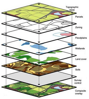
With that much spatial information it is important to understand the tools available to manage it- geographic information systems or GIS.
GIS uses computer hardware and software to collect, maintain, analyze,
visualize, and communicate spatial information. Whether you are a
private citizen, a government employee or a business person, GIS is
fundamental to helping utilize information efficiently and effectively.
 Skip to main content
